
Walk Lincoln Streets from Address to Evidence
A Lincoln street directory search works best as a chain. The county GIS viewer accepts the address and shows the parcel shape, land-use setting, and assessment parcel number. That number then becomes the key for Placer Assessment Inquiry. The resulting owner and mailing fields can be compared with the situs address, which is the taxed location. From there, the Recorder's party index can test a deed trail, while permits can add dates for construction or repair work. Each step narrows the question without treating one record as proof of occupancy.
- Enter the street address in the Placer Parcel, Zoning & Land Use Map. Select the matching polygon and record the APN, subdivision context, and map location.
- Carry the 12-digit Fee Parcel Number or Assessment Number to Placer Assessment Inquiry. Note the owner, owner mailing address, situs address, transfer date, exemptions, and assessment-cycle date when available.
- Use the owner or party name, date range, document type, and parcel description to test the Recorder's grantor and grantee index. The index supplies a reference; the recorded image is a separate access step.
- Search Lincoln's permit channel by address or parcel when a dated project, applicant, contractor, or status would help explain a change to the property.
- Use My Voter Status only for an authenticated individual, or use a qualified-purpose voter-file process. A public street-by-street voter roster is not available through the ordinary lookup.
For a past household, add a library or archive source after the current parcel is stable. A reverse directory, if a custodian confirms a local run, may connect an address to a published occupant for one year. It should be labeled as a historical clue, not a current resident result.
Lincoln Street Directory Records by Address
No single Lincoln street directory contains every person connected to a street. The records divide by custodian and by key. GIS is the address-to-parcel bridge. The assessment roll is parcel-keyed and can show owner, mailing, situs, value, and exemption information. The Recorder is party-keyed. City permits are address-keyed, while the voter channel is identity-authenticated or purpose-restricted. That split is why a street search needs a source log.
| Record Set | Keeper | Street Value | Access |
|---|---|---|---|
| GIS / LIS | Placer GIS and CDRA | Parcel boundaries, zoning, land use, situs context | Free address or APN map |
| Assessment roll | Placer Assessor | Owner, mailing, situs, values, exemptions, transfer data | Free 12-digit key; PCA503 data order |
| Recorded instruments | Placer Clerk-Recorder | Parties, document type, date, reference, title description | Online index; images at the counter or by order |
| City permits | Lincoln Building | Address, project, applicant, contractor, status, dates | Accela; City CPRA fallback for existing records |
| County permits | Placer CDRA | Unincorporated permit history | County permit channel; check jurisdiction first |
| Voter information | California SOS and Placer Elections | Residence or precinct data only through permitted access | Authenticated lookup or qualified-purpose file |
| Maps and plats | Recorder and Assessor | Subdivision, lot, block, map book, and recording reference | Map and recorded-document research |
The common thread is not a street name alone. APN, document number, recording date, subdivision, legal description, and a carefully matched party name are stronger joins. A ZIP code can help verify mail service, but it cannot replace the parcel or title key.
Lincoln GIS Street Parcels
The Placer LIS parcel application is the first stop when the only clue is a Lincoln street address. Search can use an address or parcel identifier. After the map zooms to the property, a click selects a polygon and opens Feature Info. Layers add parcel, zoning, and land-use context. They do not create an owner-name directory. The county directs owner-information questions to the Assessor, so the map and the assessment roll should remain separate steps.
| Field Label | Type | Required | Options / Format Notes |
|---|---|---|---|
| Search | Autocomplete or text | No | Address or parcel identifier. |
| Layers | Panel and toggles | No | Parcel, zoning, land-use, and related context. |
| Map click | Spatial selection | After search | Selects the parcel polygon under review. |
| Feature Info | Result panel | After selection | Selected attributes; confirm ownership with the Assessor. |
| Coordinates | Map tool | No | Displays the selected map position. |
| Dialog | No | Map layout in available portrait or landscape sizes. |
For a whole street, work visually from parcel to parcel and keep the APNs in a worksheet. The app has no detected one-click radius or neighbor-owner report. A touching polygon, a parcel across a public street, and a property in the same subdivision are different relationships and should not be merged.
Lincoln Street Owners by APN
Placer Assessment Inquiry does not offer an owner-name or street-address search in its public form. It asks for a 12-digit Fee Parcel Number, a 12-digit Assessment Number, or an Aircraft Tail Number after the user accepts the property disclaimer. For a Lincoln address search, GIS supplies the parcel key first. Property Details can then show assessment characteristics, values, ownership information, and maps, subject to the portal's notices and maintenance state.
| Field Label | Type | Required | Options / Format Notes |
|---|---|---|---|
| Fee Parcel Number | Text | One key | 12 digits; retrieves associated bills, including supplemental or unsecured items. |
| Assessment Number | Text | One key | 12 digits; returns that assessment record. |
| Aircraft Tail Number | Text | One key | Unsecured-aircraft assessment, not a street parcel. |
| Yes, I understand and agree | Checkbox | Yes | Accepts the disclaimer before the inquiry redirects to the result. |
An owner name, owner mailing address, site or situs address, map book, tax-rate area, land use, acres, exemptions, certified values, last-transfer date, and deed number may appear in the underlying assessment fields. The owner mailing address may be elsewhere. A Homeowners' Exemption can support an owner-occupancy clue, but it does not prove that every titled person lives at the property. The Assessor's office at 2980 Richardson Drive in Auburn, 530-889-4300, is the human fallback when the parcel key or owner question needs clarification.
For a street or map-book selection, the Assessor's PCA503 data request accepts the first three APN or map-book digits, assessment district or tax code, group code, or a spreadsheet of 12-digit APNs without dashes. Selectable groups include name and address, situs, certified roll values, and physical characteristics. Delivery can be by email, BOX link, or FTP in CSV or GIS formats. The published process calls for cash or check prepayment and about two weeks after payment.
Insider tip. Keep the GIS APN, assessment-cycle date, and situs-to-mailing comparison together. A free map can locate the parcel, but the Assessor is the channel for owner information.
Lincoln Address Records: Situs and Plat
Three address ideas should be separated before records are joined. Situs is the physical location used for the assessment. Mailing is where the county sends owner correspondence and can be outside Lincoln. A legal description identifies the land through a recorded description, subdivision, lot, block, or other title reference. A street number may change or be formatted differently across a deed, map, permit, and tax record, while the legal description remains the better bridge.
- Parcel
- An assessment unit identified by an APN. Assessor maps are tax aids and do not alone establish a legal lot.
- Situs address
- The location of the taxed property. It is not the same as the owner's correspondence address.
- Plat
- A recorded subdivision or parcel map that ties a development to map book, page, lot, block, or recording references.
- Criss-cross directory
- A reverse directory that starts with an address and names a published occupant for a particular year. An exhaustive Lincoln run was not verified.
The recorded subdivision index can connect a named development to a map book, recording reference, page, and lot range. That two-step bridge is useful where a marketing neighborhood name does not match the legal parcel name. Where a parcel boundary matters, recorded maps and deeds control the title question; GIS and assessment maps provide working context.
Lincoln Deed Records Behind an Address
The Placer County Clerk-Recorder index is a party and document system, not a modern street-resident roll. Once the APN, owner name, and legal description are in hand, search the current owner as grantee to locate an acquisition instrument. A grantor is the party transferring an interest. A grantee is the party receiving it. The seller in one deed can become the next earlier grantee when the chain is followed backward.
- Search the owner name in both grantor and grantee roles. Add a date range and document type when a common name produces several records.
- Compare document number, recording date, legal description, subdivision, lot or block, and APN clues before treating a result as the same parcel.
- Read the transferor as the earlier grantor, then search that person or entity as a grantee. Repeat the loop one instrument at a time.
- When an APN changes after a split or merger, bridge it through the legal description, predecessor parcel, recorded subdivision map, or lot and block reference.
The public index is free to search, but the scanned deed image is available for public research or copying in the office. Rocklin's counter is at 3715 Atherton Road, and the Auburn satellite is at 2954 Richardson Drive. Counters are open Monday through Friday, 8:00 a.m. to 4:00 p.m.; recording is 530-886-5600. A mail request needs document type, parties, recording reference, daytime phone, return address, payment, and preferably a self-addressed legal-size envelope. The county also publishes paid fax or email delivery.
Published copy information describes noncertified copies at $2 for the first page and $1 for each additional page, with certification adding a charge; the combined web description states $4 for the first certified page and $1 for each additional page. Fax or email delivery is listed at $4.25. Use the official copy order form and confirm the current amount with the Recorder before mailing a request.
Lincoln Permits Add Dates to Street Records
Lincoln permit records can explain when a building, pool, sign, utility connection, right-of-way project, or residential improvement changed the visible story of a parcel. The Lincoln Accela portal is the current city entry point. The City permit index distinguishes building, alarm, business, fireworks, golf-cart, home-business, marijuana-cultivation, pool, residential, sign, special-event, block-party, encroachment, transportation, utility, and hydrant services. A permit identifies an applicant, owner, contractor, project, status, or date when those fields are public. It does not prove who lived at the address.
The Lincoln permit screen below is useful because its address-keyed project trail can be compared with an assessment transfer or deed date.
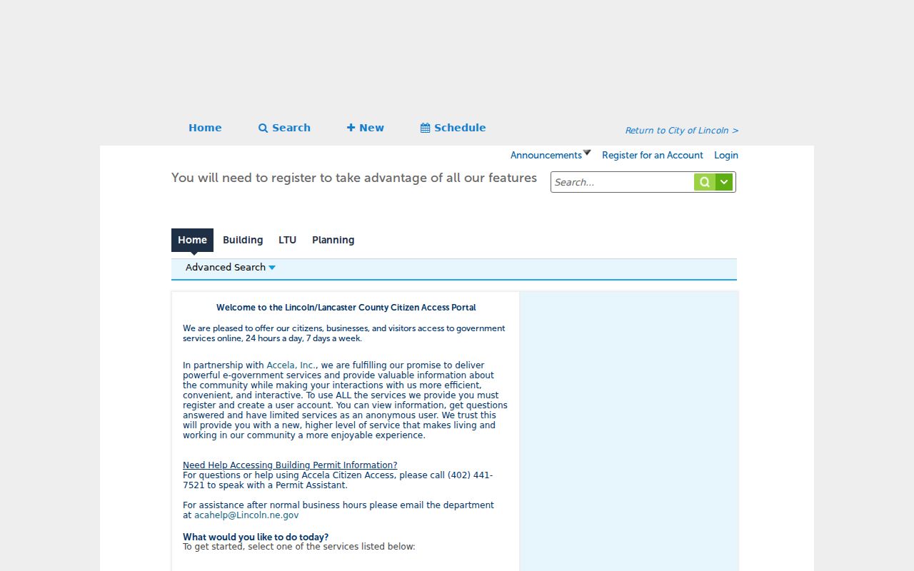
Current residential over-the-counter applications can be emailed to the City's permit channel, followed by Citizen Portal payment. Inspection requests made before 3:00 p.m. are scheduled no earlier than the next business day. For older or unindexed city files, the Lincoln public-records channel accepts online, email, in-person, or phone requests. The City Clerk asks for a specific record, dates, and identifying details; reproduction charges can apply.
Jurisdiction matters. A parcel that uses a Lincoln mailing address but lies outside incorporated Lincoln may belong with Placer CDRA for permits and county records. Check the city boundary and parcel location before concluding that no permit record exists.
Read Lincoln Streets Through Planning Geography
Address records gain meaning when the parcel is placed in the right planning area. Lincoln's planning materials include an address and parcel searchable zoning map, a Lincoln Neighborhood Subdivisions Map, and a General Plan 2050 framework with seven Villages and three Special Use Districts. Specific-plan material identifies Village 1, Village 5, Village 7, Independence, and the Northeast Quadrant or SUD-B. A 2023 public notice concerned sphere-of-influence changes and Village 5/7B annexation.
The Lincoln Planning and Development resources help distinguish an incorporated parcel, a planned growth area, a named subdivision, and a county parcel with a Lincoln mailing address. They do not publish a resident roster. Subdivision names are useful search terms, but the exact recorded declaration or map should be used before treating an association or neighborhood label as a legal parcel fact.
Research did not verify a Lincoln-specific street-renumbering history or a city E911 addressing rule. When an old street reference looks different, preserve the original wording and test the APN, map, deed legal description, and nearby cross streets rather than inventing a renumbering date.
What Voter Records Add to Lincoln Streets
California's My Voter Status service is an authenticated individual check. It asks for first name, last name, date of birth, and, when applicable, a California driver license or ID number or the last four digits of a Social Security number. An authenticated result may show the person's own registration status, party preference, residence, precinct or districts, polling or vote center, vote-by-mail, and ballot status. It never shows ballot choices.
Placer Elections is the local administrative contact at 3715 Atherton Road in Rocklin, 530-886-5650, Monday through Friday, 8:00 a.m. to 5:00 p.m. Voter-file access under Elections Code sections 2188 and 2194 and 2 CCR sections 19001-19013 requires a qualified purpose. Specific voter requests require a full name, date of birth, county, and residence address, with a published $30 fee per record, a maximum of ten, and a $100 ceiling. Commercial use is prohibited, and protected addresses may be suppressed.
Myth check. California does not provide a casual house-by-house voter directory. The self-service result is for the authenticated voter, while a permitted file is a separate regulated channel.
That limit changes how an address search should be worded. Voter information can corroborate an authorized research question about residence or precinct, but it cannot be used as an anonymous block browser. Safe at Home participants and other confidential voters are a lawful reason for a missing result.
Find Older Lincoln Addresses in Reverse Directories
A conventional directory moves from surname to address. A criss-cross or reverse directory moves from address to a published occupant for a specific year. That distinction matters when a house history concerns people who were present but not named in a deed. The Lincoln research did not verify an exhaustive local reverse-directory run, so a search request should ask the librarian for a publisher, title, year, and address index rather than assume that a volume exists.
The verified historical anchor is the FamilySearch catalog record for the 1861 Placer County directory. FamilySearch identifies the original as held by the Lincoln Area Archives Museum and the digital image group as DGS 104933440. The catalog proves the title and provenance, but the inspected research did not expose a readable Lincoln entry or an abbreviation key. Do not assign an occupant, occupation, or owner status to that volume without inspecting the page.
Lincoln Public Library is city-run, while the nearest Placer County Library branch is in Rocklin. Twelve Bridges Library is at 485 Twelve Bridges Drive, 916-434-2410; its Ancestry access is in-building, while HeritageQuest is offered remotely with a library card. The two library systems may offer different catalog access and databases. Ask for a street index, local-history referral, or reverse-directory confirmation. A directory entry can supply a valuable publication-year clue, but it should be paired with a deed, census, newspaper, or other independent record.
Lincoln ZIP Records and City Limits
Lincoln's verified standard postal ZIP code is 95648. USPS assigns a ZIP for mail delivery, not for municipal governance. A Lincoln, California, 95648 mailing address can lie outside incorporated Lincoln, while a city parcel and a postal boundary answer different questions. Use the USPS ZIP lookup to verify one mailing address, then compare the result with Placer GIS and Lincoln planning geography.
Do not create a ZIP-wide owner or resident list from the public portals. GIS searches by address or APN. Assessment and tax tools require a 12-digit key. City zoning and subdivision maps use address or parcel. My Voter Status authenticates one person. For a lawful area study, build an APN set from the map, then use the Assessor's documented data-request route. A ZIP filter alone is not evidence that two records describe the same jurisdiction.
New villages, annexation proposals, subdivisions, council districts, election precincts, school zones, and postal routes can overlap without sharing a boundary. An address search should preserve the ZIP, city-limit status, subdivision, and parcel source date as separate fields.
What the Lincoln Street Directory Cannot Reveal
Address records can show a titled owner, a mailing destination, a parcel shape, a recorded party, a permit applicant, a precinct, or a published historical occupant. They do not create an open list of household members. Utility customer records, DMV addresses, private association membership, unlisted phone data, and protected voter addresses are not ordinary street-directory fields. Even a current owner may live elsewhere, and a permit applicant may be a contractor or representative.
California's privacy rules also restrict comprehensive vital-record indexes and personal voter data. Safe at Home supplies a substitute mailing address for covered participants. The California Public Records Act can request existing nonexempt city or county records, but it cannot force an agency to create a new street roster or disclose information made confidential by another law. A careful result records what the custodian actually shows and stops when the source stops.
Lawful personal use. Lincoln street and parcel research belongs in family history, property history, civic review, and personal safety work. Stalking, harassment, threats, or unlawful use of identifying information can violate California Penal Code sections 646.9 and 530.5 and other remedies.